
Hike, Walk, Bike
on the many trails found in
Wolfeboro and Tuftonboro or
just a short drive in the
Lakes Region of NH
- Abenaki Tower, Rt 109, Tuftonboro
(across from Wawbeek Rd)
Beginner: .3 miles round trip, elevation 745′.
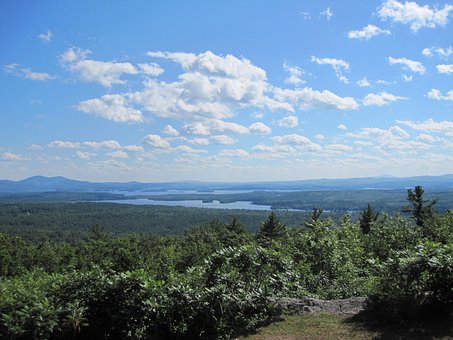
Views of Lake Winnipesaukee and Belknap Mts.More…
- Bald Knob , Rt 171 Moultonborough
(parking same as Shannon Brook Trail)
Moderate: 4 miles round trip, elevation 1801. Views of Lake Winni, Belknap Range, Castle in the Clouds. More…
- Bridge Falls Path & Cotton Valley Trail
Wolfeboro-Wakefield
Walk, Run or Bike this trail. Access anywhere along the trail from train station, downtown Wolfeboro, Foss Field at Back Bay, Mast Landing, Albee Beach, Fernald Crossing and continues to Wakefield.
- Caverly Mountain
Calverly Mt Road, New Durham/Brookfield More…
Moderate: 1433′
Castle in the Clouds, 455 Mt Rd (Rt 171) Moultonborough
28 miles of hiking trails More…
- Copple Crown Hike
Brookfield
Hike to the summit of Copple Crown Mt and eastern knob called East Peak. Views of Lake Winnipesaukee and more.
2.75 miles (one way) gradual, moderate and steep areas. Overall elevation 1,100′. Hiking time approx 3.5 to 4 hours
- Devil’s Den
off of Hays Rd, Alton More…
1 mile round trip: great views of the area More…
Wildlife viewing area located on Rt. 109 on the north end of Lake Wentworth.
- Ellis R Hatch Jr Wildlife Management Area
Formerly known as Jones Brook WMA
Kings Highway, Brookfield
1492 acres: Hiking, fishing More…
- Fall of Song and Brook Walk
park 1.5 miles up Ossipee Park Rd, Moultonborough
Beginner: 1.2 miles round trip. Scenic Sharon Brook is the source of seven pretty waterfalls and cascades, including the 40-foot Fall of Song. Brook Walk is a scenic hike along the brook, passing all seven cascades. The trail begins at Shannon Pond. More…
- Front Bay Conservation Area,
Bay St, Wolfeboro
Wood trail to Back Bay with viewing and picnic area. Handicapped accessible.
Beginner, elevation 310′, 1 mile round trip. View Squam, Ossipee and Sandwich Ranges More…
- Knights Pond Trail
Knights Pond Rd, Alton More..
.4 mile from parking lot to pond. 1.4 mile loop around pond.
- Moose Mt Reservation
Middleton/Brookfield
Trails are a combination of woods roads, snowmobile trails, and foot paths.
Strenuous: 7 mile round
trip, elevation 2395
- Mt Major
Rt. 11 in Alton, NH, 5.4 miles north of Rt. 140, Alton More…
Moderate: 3.1 mile round trip, elevation 1786
panoramic view of Lake Winnipesaukee
Moderate: 5.5 miles, elevaation 2,582′ More…
- Mt Shaw, Tuftonboro
Trailhead and parking areas: Rt 25, 3.9 miles east of rt 109, Tuftonboro.
Also: East of Sodom Road, over a bridge, is the parking area. It is on the north side of the road.
Difficult: 7.3 miles, elevation 2990′ More…
- Ossipee Pine Barrens Ossipee, Freedom, Madison & Tamworth, NH (
View Map
7.5 miles of hiking trails in the preserve provide terrific opportunities to explore the Ossipee Pine Barrens Preserve. The 1.3 mile Pine Barrens Loop begins at the preserve parking area along Route 41 in Madison and offers an easy excursion through classic pitch pine/scrub oak barrens, while the 3.2 mile West Branch (accessible) Trail is a popular snowmobile trail… You can also canoe or kayak on Cook’s River and Pond… More… - Red Hill Fire Tower, Moultonborough
Beginner: 3.4 miles round trip, elevation 2030′. Views of Lake Winnipesaukee and Squam Lake. More…
quiet and scenic 179-acre woodland for walking, biking, cross-country skiing. Connects to Town’s Abenaki trail network, providing a total of over 18 miles of trails.
- Tumbledown Dick,
Tumbledown Dick Rd, Brookfield and 742 Pleasant Valley Rd, Wolfeboro (Brookfield)
Brookfield: Moderate 1+ mile
Wolfeboro: Moderate 2- miles
- Wolfeboro Singletrack Alliance (WSA)
Trails designed for mountain biking.